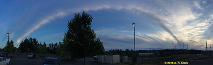
I estimate the origin at right to be due west of Seattle or thereabouts. The camera was about 11 miles south of Everett along Interstate 5 at Exit 183. The panorama spans from roughly west by northwest at right to east by southeast; the apparent path of the stream of cloud is approximately to the southeast.
As the cloud mass continued (southeastward?) the entire mass gradually lowered and appeared to be forming into a uniform high thin layer. I watched the spectacle for about 25 minutes; the panoramic photo was made at 8:57 PM.
Local weather news reports the approach of a storm from the Gulf of Alaska due to bring rain and/or cool weather before the weekend.
To grasp the scale note that the right side of the image is at west over the Olympics, the left side is at east over the Cascades, and the picture spans the entire evening sky. The estimated visible extent of the clouds is about 100 miles. Click the photo for a larger view.
This is the only such phenomenon I have seen in 73 years. RC